


Marine Navigation
3.542.00 Reviews
App Specs
- Version
- 16.8.18
- Updated On
- License
- $19.99
- Downloads
- 10,000+
- Developer
- Marco Palaferri
- Categories
- Maps & Navigation
- Platform
- Android
Screenshots
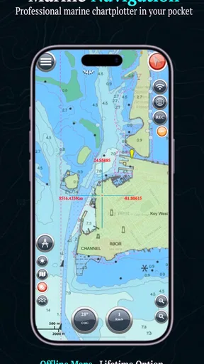
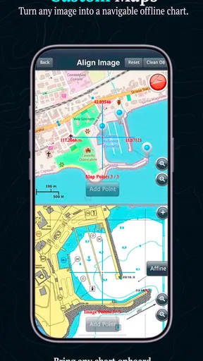
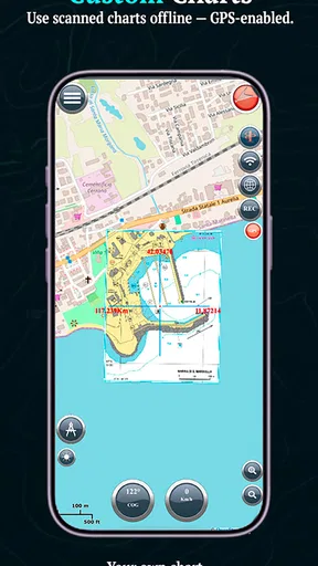
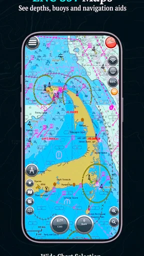
 Analysis by AppCompare
Marine Navigation is the kind of app that makes sense only when you have a clear reason to carry detailed marine charts on your phone. I approached it as a practical navigation tool rather than a casual map app, and that distinction matters. It is built for people who spend time on the water and want access to S57 and custom maps, while also placing unusual emphasis on privacy and a one-time purchase model.
My first impression was that this is a focused tool, not a polished travel companion designed to appeal to everyone. The short description, “Marine Navigation,” is accurate but modest. The real appeal comes from the chart-oriented workflow: preparing information before leaving, checking position during a trip, and keeping a familiar map setup available without depending entirely on a general-purpose navigation service.
Developed by Marco Palaferri, the app sits in the Maps & Navigation category and has been available since July 11, 2012. That long presence gives it a more established feel than a brand-new charting experiment, although its average rating of 3.5 from around 431 ratings also tells me that the experience is not universally effortless. I would recommend approaching it as a specialist instrument whose value depends heavily on your habits and expectations.
What the first week feels like on the water
During the first week, the strongest attraction is the sense of control. Instead of treating marine navigation as a simplified version of driving directions, Marine Navigation is aimed at chart use. S57 support is particularly relevant to boaters who already work with official or structured electronic chart material and do not want their entire workflow reduced to a consumer map interface.
Custom maps are another reason to pay attention. They can make the app more useful when your preferred local reference material does not fit neatly into the standard experience. The important practical point is that custom mapping is not automatically convenient just because it is supported. You need to think about which charts you trust, how you organize them, and whether you can identify the right map quickly when conditions change.
I would spend the first sessions at home rather than waiting until departure day. Open the app, inspect the available chart material, and learn how the map behaves before you are dealing with glare, movement, poor reception, or a busy cockpit. A navigation app should reduce decisions underway, not introduce a new set of them.
That preparation also answers a question many new users have: can this replace a dedicated marine navigation setup? In my view, it should be treated as a supporting tool unless you already understand its chart workflow and have tested it in the environments where you plan to use it. A phone is convenient, but convenience does not remove the need for proper nautical planning or backup equipment.
Worth Reading Before You Choose

Flipboard Shows What News Apps Must Do Beyond the Feed

Switching to Android Auto Means Rethinking Your Driving Routine

Google Calendar Makes a Crowded Week Easier to Manage

Ludo King Makes the Most of the Minutes Between Plans

Baby Panda World Brings Quick Play to Modern Phones, but Its Game Library Feels Busy

ESPN’s Live Game View Makes Following Close Games Easier
The first-week novelty comes from seeing a phone handle specialized chart material instead of ordinary street maps. That is satisfying, especially if you enjoy configuring your own tools. However, the novelty fades quickly if you only need occasional directions to a marina. For that user, a familiar general map app may be faster and less demanding.
Custom charts reward preparation, not improvisation
One of the less obvious trade-offs is that custom maps shift responsibility toward the user. They may give you a better match for a particular area or personal workflow, but they also make naming, storage, and selection more important. I would keep a simple chart routine: organize material by region, use recognizable names, and check the intended chart before setting out.
This is not busywork. A cluttered chart collection can turn a useful feature into a source of hesitation. The app is most convincing when your custom material is curated rather than accumulated. If you download or create maps without a system, the flexibility can become friction.
Another useful first-week test is to compare the app with the charts or navigation tools you already use. Look at the same coastal area in both and ask which view helps you make a decision faster. The answer may vary by task. Marine Navigation can be more suitable for a chart-focused workflow, while a mainstream alternative may be better for finding a business, planning a road journey to the launch point, or sharing a simple destination with another person.
Privacy and payment shape the experience
The privacy-focused positioning is meaningful to me because navigation apps can feel intrusive when they constantly depend on accounts, advertising, or location-based personalization. Marine Navigation presents itself as respectful of privacy, which makes it attractive to users who prefer a more self-contained tool. I still recommend reviewing the app’s behavior on your own device and being deliberate about location access, as I would with any navigation software.
The price is $19.99, and that is a serious commitment compared with free map apps. The trade-off is that the product is presented around a one-time purchase rather than a standard subscription. There are also in-app purchases of $5.99 per item, so I would not assume that the initial payment covers every possible chart or add-on need. Before buying, I would decide whether the app will be used often enough to justify the upfront cost and whether the available map workflow matches the areas you navigate.
For a regular boater, paying once can feel more comfortable than building a permanent monthly bill. For someone who takes one boating trip a year, the calculation is less favorable. The purchase makes the most sense when the app becomes part of a repeated preparation routine, not when it is installed for a single weekend out of curiosity.
Why it can keep earning space month after month
Long-term value comes from repetition. If I were using Marine Navigation regularly, I would judge it by how quickly I could prepare a familiar trip, retrieve the right map, and check my position without fighting the interface. A specialist app does not need to entertain me after the first week; it needs to remain dependable and understandable when I return to it after a gap.
The strongest recurring use case is a boater who visits the same broad region but explores different routes, anchorages, or coastal areas over time. S57 support can make the app relevant for structured chart users, while custom maps offer room for a personal collection. Together, those capabilities give the app a reason to remain installed instead of becoming a one-trip experiment.
A realistic scenario would be preparing for an early morning coastal outing. The night before, I would open the app, identify the chart covering the planned area, check that the custom material is the one I expect, and make sure the phone is ready for use. On the water, the value is not flashy automation; it is having a known chart view available when I want to confirm where I am and maintain awareness of the surrounding area.
That workflow also reveals a limitation: the app does not remove the need for judgment. It can be part of navigation, but it should not encourage anyone to follow a screen blindly. Weather, visibility, local hazards, vessel capability, and ordinary seamanship still matter. I would use it as one layer of awareness, alongside appropriate charts, equipment, and planning.
The habit that makes the purchase worthwhile
To keep the app useful, I would create a small pre-departure checklist around it. First, select the relevant chart or custom map. Next, inspect the route area at a comfortable pace rather than zooming around in a hurry. Then confirm that the phone is charged and positioned where it can be read safely. Finally, keep a backup navigation method available.
This routine is a concrete advantage because it turns a flexible app into a predictable instrument. It also exposes whether the product really fits your life. If you repeatedly forget how your maps are organized or avoid opening the app until the last minute, the long-term value will be lower than the feature list suggests.
I would also avoid treating every custom map as equally authoritative. Personal or imported material may be useful for context, but I would distinguish it clearly from the chart information I rely on for navigation decisions. That separation is one of the most important practical habits for anyone using the customization side seriously.
Where recurring value drops off
Marine Navigation is less compelling for people who want automatic route suggestions, a broad travel-planning ecosystem, or a highly social experience. A general navigation service may be better for getting from home to a harbor, finding fuel or restaurants, and coordinating a trip with friends. A dedicated marine platform may be preferable for users who want a more comprehensive package built specifically around their vessel and sailing routine.
The app’s audience is narrower than the word “navigation” might imply. It is not simply a replacement for every map on your phone. Its lasting value depends on whether S57 and custom map support solve a real problem for you. If they do, the focused design can be a strength. If they do not, the purchase may feel excessive.
The public adoption level also suggests a specialized community rather than a mass-market tool: it has over 10K installs. I do not read that as a quality verdict, but it does reinforce my impression that this is aimed at a particular kind of user. I would be comfortable recommending it to someone who already understands marine charting, but I would guide a complete beginner toward learning the basics before depending on any chart app.
Maintenance is the hidden cost of a flexible chart app
The maintenance burden is not only about installing updates. It is about keeping your chart collection understandable and your operating routine current. The current version is 16.8.18, and the minimum requirement is Android 6.0, so the app supports a broad range of devices. Even so, I would test it after major phone changes, operating system updates, or a long period without use.
Before an important trip, open the app while you still have time to troubleshoot. Check that your maps are visible, that the display is comfortable to read, and that the device behaves as expected. This is especially important when custom maps are part of your setup. A map that worked months ago is not useful if you cannot find it quickly now.
Chart management can become a recurring chore. The more regions and custom files you collect, the more valuable a tidy naming convention becomes. I would keep only material that I can identify and explain, rather than allowing the app to become a storage box for every chart I have ever encountered.
There is also a human maintenance cost. If you use the app only sporadically, you may forget the controls and the meaning of your own map organization. A short refresher before each season or trip is sensible. That is not a criticism unique to this product; it is a direct consequence of choosing a specialist tool over a simpler, more familiar alternative.
What I would check before relying on it
I would verify the app in a safe setting, not during a demanding passage. Test the chart view in daylight and at the brightness level you expect to use. Confirm that the map you intend to use covers the whole working area. If you switch between standard and custom material, practice that transition until it feels routine.
I would also make sure other people on board know what the app is being used for. If the phone is handed to someone else, they should understand whether they are looking at a planning reference, a position display, or a chart intended for active navigation. Clear expectations reduce the risk of treating a convenient screen as a complete navigation system.
Because the app is rated for Everyone, it is broadly accessible from an age-rating perspective, but that should not be confused with being effortless for every experience level. Marine navigation itself requires context. The app can be approachable as software while still demanding responsible use from the person holding the phone.
Sources of fatigue after the novelty fades
The first source of fatigue is setup. Users who enjoy arranging charts may see this as useful control, while others may see it as work that should have been handled automatically. The same custom-map capability can therefore feel like the app’s best feature or its biggest obstacle, depending on how much preparation you are willing to do.
The second is the gap between a specialist chart tool and the convenience of mainstream apps. General map applications are often better at ordinary location searches and everyday travel tasks. Marine Navigation is more interesting when the question is about marine chart material, not when I simply need to locate a shop near the harbor.
The third is financial commitment. At $19.99, the app asks me to decide before I have built a long usage history. The one-time purchase model is appealing, but the additional $5.99 per-item in-app purchases mean I would examine the complete cost of my intended setup rather than stopping at the headline price.
The fourth is trust calibration. A clean chart display can create a false sense of certainty. I would resist using any mobile chart app as my only safeguard, particularly in unfamiliar waters or changing conditions. The product earns its place when it improves awareness and preparation, not when it encourages overconfidence.
Finally, the rating of 3.5 is a useful reminder to keep expectations realistic. With around 42 written reviews, there is enough public feedback to show that experiences vary, but not enough to make the app feel universally validated. I would interpret that as a reason to test the workflow personally before making it central to my navigation habits.
Who should keep it installed?
I think Marine Navigation is best for boaters who specifically want S57 support, custom maps, and a privacy-conscious alternative to more account-driven navigation products. It is also a reasonable fit for someone who prefers paying once and maintaining a personal chart workflow over subscribing to a larger service.
I would be more cautious recommending it to a casual holidaymaker, a person looking for turn-by-turn road directions, or anyone who expects the app to organize every part of a boating trip automatically. Those users may get more immediate value from a mainstream map service or a more comprehensive marine package, even if that means accepting a subscription or a busier interface.
For a friend who regularly goes out on the water, I would say this: buy it only if you are prepared to learn the chart workflow and keep it organized. The app can become a dependable part of preparation, but it is not a magic shortcut. Its usefulness grows with familiarity, especially when custom maps are involved.
My long-term verdict is cautiously positive. Marine Navigation earns lasting space when I use it as a focused chart companion, return to it regularly, and maintain a clear system for my maps. Its privacy-oriented approach and one-time purchase model are appealing, and S57 plus custom-map support gives it a distinct purpose.
It does not earn that space simply because it is a marine app. The price, setup responsibility, possible extra purchases, and need for responsible backup planning all matter. After the first-week appeal fades, the deciding question is straightforward: will you repeatedly use its specific chart capabilities? If the answer is yes, this is a focused tool worth learning rather than a disposable download. If the answer is no, a simpler everyday map app will probably serve you better.
Pros
- Detailed nautical charts support safer route planning.
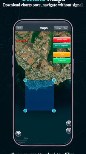
- Offline maps remain useful when sailing beyond mobile coverage.
- GPS tracking shows your real-time position on the water.
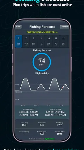
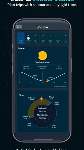
- Weather and tide information can improve trip preparation.
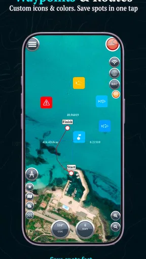
- Waypoints and route tools make it easier to organize voyages.
Cons
- Some advanced charts or features may require a paid subscription.
- Chart accuracy can vary by region and update frequency.
- GPS performance may drop in poor weather or obstructed areas.
- The interface can feel complex for first-time marine navigators.
- Battery use may increase during long trips with GPS enabled.
FAQs for Marine Navigation
What is Marine Navigation, and who is it designed for?
Marine Navigation is a navigation app intended for boat owners, sailors, anglers, and other people who spend time on the water. It can help users plan routes, view nautical information, check their position, and navigate using a mobile device. Before downloading, beginners should understand that the app is a supporting tool and should not replace official charts, navigation training, local regulations, or proper onboard safety equipment.
Does Marine Navigation work without an internet connection?
The app may offer offline access to selected maps or navigation data, but this usually depends on downloading the required charts or regions before leaving shore. GPS positioning can often continue without mobile data, although map updates, weather information, traffic details, and online services may require an internet connection. It is important to test downloaded content in advance and avoid relying on the app if offline coverage has not been confirmed.
Can Marine Navigation be used for real boating trips?
Marine Navigation can be useful during real trips for checking position, following a planned route, and reviewing navigational information. However, smartphone navigation has limitations, including battery consumption, poor visibility in sunlight, water exposure, signal problems, and possible chart inaccuracies. For safer use, keep official nautical charts, a compass, emergency communication equipment, and another reliable navigation method available, especially when sailing offshore or in unfamiliar waters.
What permissions and equipment does Marine Navigation require?
The app generally needs access to your device’s location so it can display your position and calculate routes. Depending on its features, it may also request permission for internet access, notifications, storage, or Bluetooth connections to external marine instruments. A compatible GPS-enabled phone or tablet is recommended. Users should review permissions carefully and remember that continuous GPS use can significantly reduce battery life during longer journeys.
Is Marine Navigation free, or does it include in-app purchases?
Marine Navigation may be available as a free download while keeping advanced features behind subscriptions or in-app purchases. Premium options can include detailed nautical charts, additional map regions, weather layers, route planning tools, offline downloads, or removal of advertising. Pricing and available features can vary by platform and country, so check the current store listing before downloading and confirm whether subscriptions renew automatically.


